Capability of CPAS in predicting Tropical Cyclone Ma-on
Background of the cyclone
Ma-on originated from a low-pressure area over the ocean east of the Philippines as early as August 19, 2022. On August 22, the Japan Meteorological Agency upgraded the system into the Tropical Storm and gave it the designated name “Ma-On”. Ma-On intensified into a Severe Tropical Storm when it approached the Philippines. It moved across Luzon, the Philippines, and then travelled to the South China Sea. It finally made landfall at Dianbai District (Tinpak), Guangdong Province, China on August 25.
Many of the numerical weather prediction models from the public agencies had ever forecasted that Ma-on would make landfall to the east of the Pearl River Delta Metropolitan Region early. However, the reality is that it made landfall to the west of that. In the following, we would like to discuss the capability of CPAS in predicting this event.
Mesh specification
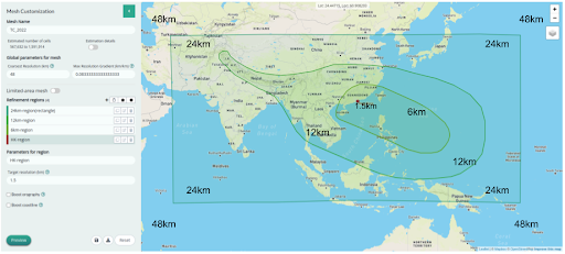
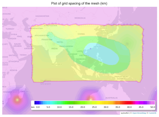
We have specified the region of 6km-, 12km- and 24km- resolutions covering the potential typhoon tracks and the Southeast Asia and Western Pacific Ocean, with 1.5km in respect to Hong Kong as shown in Figures 1a and b.
Prediction by CPAS versus other models
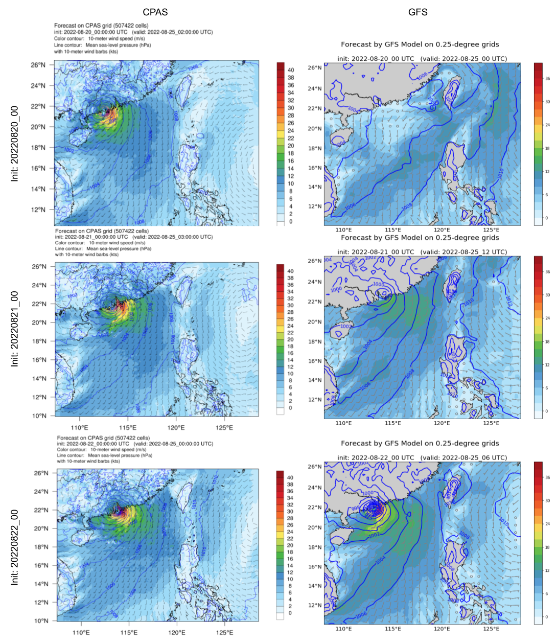
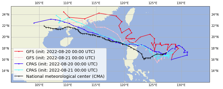
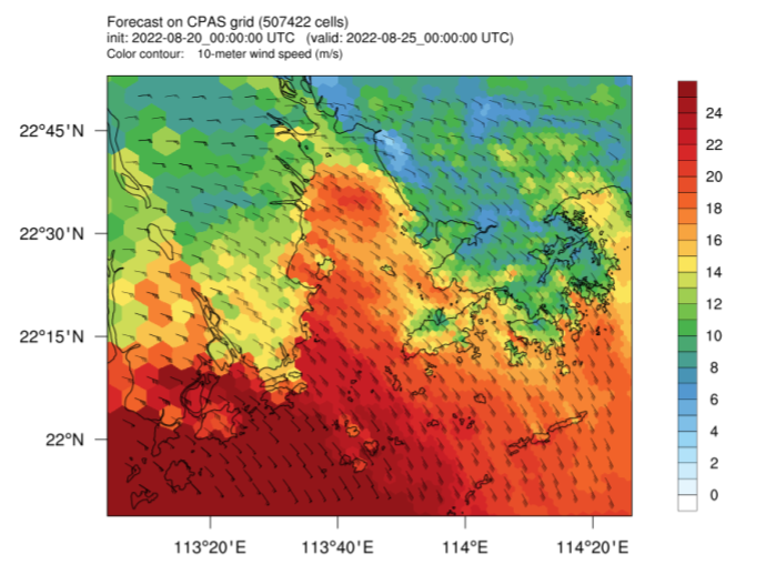
In Figure 2a, we can see that CPAS model can consistently predict the TC Ma-on would make landfall to the west of Hong Kong in different runs. As early as the run of 20220820_00, which is a five-day ahead forecast to the landfall event, CPAS could predict that the TC Ma-on would make landfall at Yangjiang, Guangdong Province, which is relatively closer to the actual landfall location compared to other models. The American global forecast model (GFS) predicted that the low-pressure area would go to the Taiwan Strait in the run 20220820_00.
Meteorological analysis of the motion of Ma-on by CPAS
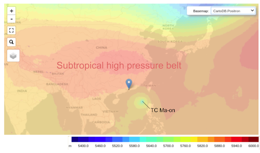
The subtropical-high aloft South China drove the Tropical Cyclone Ma-on a westward motion. The geopotential height at 500hPa in Figure 3 shows that the subtropical high can be predicted by CPAS.
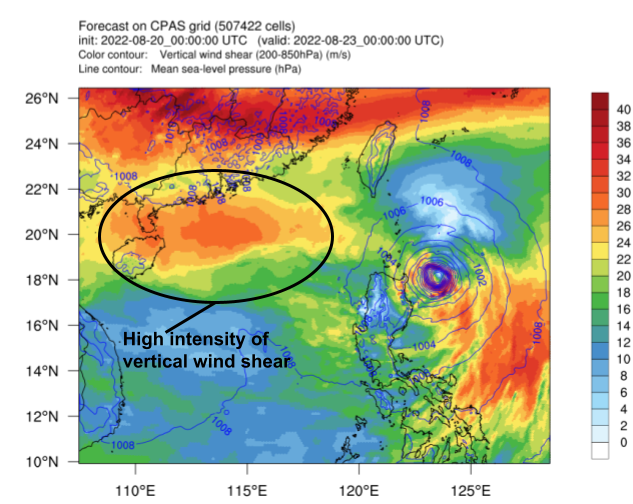
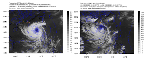
CPAS can also predict that the wind shear is strong in the Northern South China Sea. In Figure 4, we can see that the predicted wind shear of 200-850hPa, a usual indicator of the wind shear effect to typhoons (Uddin et al., 2021; Finocchio, 2017), exceeded 25 m/s. The high intensity of vertical wind shear inhibits the growth of Ma-on. CPAS even predicted the convection at the northern part of Ma-on is relatively weak when it moved to the South China Sea as seen in Figure 5.
Local wind situation
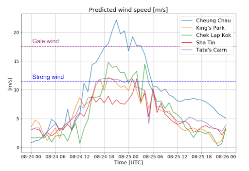
For the local wind situation in Hong Kong, we have used 1.5km resolution for the region covering Hong Kong in this global mesh. The effect of local terrain features on the wind can be resolved. By using barycentric interpolation, the predicted wind speed (from the run 20220820_00 UTC) at certain stations can be obtained.
Summary
Due to the customised resolution features, the computational resources can be flexibly assigned. In this case, the fine-resolution part has intensively covered the potential track of the cyclone and the related synoptic weather systems.
CPAS is able to predict cyclogenesis early. The fine resolution can also favour the simulations of the convection development at the inner part of the cyclone and its interaction with the land during the developing stage of the cyclone.
The fine resolution can also help predict wind speed at the local stations in this global model, especially that the local effect can be considered.
Reference
Md. Jalal Uddin, Zahan Most. Nasrin, Yubin Li, Effects of vertical wind shear and storm motion on tropical cyclone rainfall asymmetries over the North Indian Ocean, Dynamics of Atmospheres and Oceans, Volume 93, 2021, 101196, ISSN 0377-0265, https://doi.org/10.1016/j.dynatmoce.2020.101196.
Finocchio, Peter M. , The Structure of Vertical Wind Shear in Tropical Cyclone Environments: Implications for Forecasting and Predictability, University of Miami ProQuest Dissertations Publishing, 2017. 10607675.